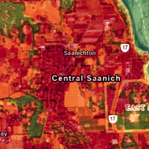
With summer approaching and anticipation for rising temperatures growing, our team at Caslys reflected on some of the past heat waves in recent memory and dove into some current extreme temperatures being experienced elsewhere in the world. Analysis Completed using CARD Stack Services June of 2021 stood out to many of us in the Victoria region, with record breaking high temperatures causing city wide stress and even pushing businesses to close due to both health and technical issues. Leveraging our CARD Stack services, the Caslys team accessed analysis-ready datasets to further investigate the 2021 heat dome experienced across southern Vancouver Island. Our approach focused on Land Surface Temperatures (LST) as a key parameter. LST differs from classic weather report temperatures, also know as atmospheric (air) temperatures. It is a measurement of ground or surface temperature to the touch, and is an effective weather index that shows variability for studies at regional and global scales. While weather stations and local sensors can provide temperature data, remotely sensed imagery data has proven to be a great source of accurate temperature distributions at high spatial and/or temporal resolutions¹. After acquiring 10 years of Landsat 8 imagery over multiple June dates for the CRD, the LST was calculated and used in this case study to create strong visual indicators of surface temperature extremes. The June 21st, 2021 image showcases the abnormally high surface temperatures experienced across the Saanich Peninsula, reaching upwards of 40oC. This is more than double the expected June temperature high, which between 2000 and 2024, is about 17oC according to historical data. Areas with forest and tall vegetation were much cooler relative to developed areas with concrete or pavement, causing extreme urban heat island effects. Heat Waves Around the World Parts of Mexico and India recently experienced similar abnormal heat waves […]
Continue readingAuthor Archive: Caslys
Explore the Best Garden Centres and Nurseries in Victoria
We’re celebrating 2022: the Year of the Garden! To get into the spirit of gardening, the web mapping team at Caslys has created an interactive plant resources map showing the locations of local garden centres and nurseries in Victoria and the surrounding Capital Regional District. Whether you are looking for supplies or inspiration, you’ll find what you need in our app. The Year of the Garden is a celebration of the many ways in which the practice of gardening can enrich our lives. Gardening connects us with the Earth, and the practice can be both relaxing and invigorating. At Caslys, we’re lucky to be surrounded by an abundance of plant shops for the novice and expert alike. Click on the image below to explore the resources featured in our garden app. It’s time to get inspired and get growing this year! To learn how web mapping applications can bring your projects to life, contact the Caslys web mapping team today.
Continue readingCaslys COVID-19 Safety Plan
Statement of purpose Caslys is committed to providing a safe and healthy workplace for all staff, as well as others who may enter our premises. Our COVID-19 Safety Plan outlines measures that we are taking to reduce the risk of COVID-19 transmission in our workplace. Development of the safety plan The policies and procedures outlined within the Caslys COVID-19 Safety Plan are based on guidance published by the Provincial Health Officer, the BC Centre for Disease Control and WorkSafeBC. Caslys will modify this plan and any procedures if they are not effective and working as necessary. Questions or concerns regarding compliance with our COVID-19 Safety Plan may be directed to the owners of Caslys via phone or email: Jason Shaw (jshaw@caslys.ca; 250-686-8801) or Luanne Richardson (lrichardson@caslys.ca; 250-884-6481). Protocol for reducing the risk of COVID-19 transmission We prohibit all our staff from reporting to work if they have COVID-19. They may return to work only if they meet one of the following conditions: Fever completely gone for at least three days AND improved respiratory symptoms (cough, difficulty breathing) AND at least five days have passed since the initial onset of symptoms. Fever completely gone AND improved respiratory symptoms (cough, difficulty breathing) AND negative results from the public authority’s COVID-19 testing protocol (to date = two negative tests 24 hours apart). If staff present illness symptoms, they may be excused from work without requiring a doctor’s note. Staff must report respiratory illness to Jason Shaw or Luanne Richardson and cannot return to work for at least 5 days following the onset of cough, fever, fatigue, sore throat, runny nose, difficulty breathing and/or shortness of breath. If a staff member is sick or has known close contact with someone who had COVID-19, they should work from home for a minimum of 5 days after exposure. Contact 8-1-1 if […]
Continue readingCaslys Helping to Map Extents and Impacts of Recent Flood Emergency in BC
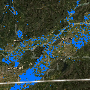
As the rainy season begins to unfold throughout the Pacific Northwest, the southern portion of British Columbia saw a historic atmospheric river condition that brought with it high volumes of precipitation and extensive flooding. The impacts to communities, transportation, agricultural and human life were unprecedented – triggering a state of emergency for many jurisdictions. In response to this natural disaster, Caslys has used publicly available satellite imagery (both Sentinel-1 RADAR images and Sentinel-2 optical imagery from the European Space Agency) to rapidly assess flood conditions in both the Fraser Valley, areas around the communities of Merritt, Princeton and the southern portion of Vancouver Island. Cloud penetrating RADAR imagery from before the flooding was compared to images taken on November 16th when the flood was near its peak. The results show very clearly where the land is inundated with floodwaters. Caslys then incorporated the Land Cover Atlas for Urban and Rural BC dataset that we developed for the Ministry of Forests, Lands, Natural Resource Operations and Rural Development to assess the flooding with respect to land use types such as agricultural fields, roads and parklands. The dataset covers much of the Fraser Valley Regional District (FVRD) plus Langley and Maple Ridge within Metro Vancouver Region. The most extensive flooding was found with over 1205 hectares of agricultural lands flooded in Abbotsford, 257 hectares in Chilliwack and 296 hectares in other municipalities. Major flooding also occurred across more than 10 kilometres of road surface. Caslys has provided the results and methods of our analysis to geomatics professionals at Emergency Management BC which is playing a key role in providing data and resources to assist in the flood response. We hope that our work augments the detailed monitoring efforts that they are implementing to assist in key impacted areas of the province. Our […]
Continue readingGolf FORE KidSport Fundraising Event: A Record-breaking Success!
Earlier this month, KidSport Greater Victoria hosted the Golf FORE KidSport fundraising event – and it was an outstanding success! After so many months of not being able to participate due to the pandemic, more and more kids are finally getting back into sports. This year, the annual tournament raised a record-breaking $32,388! That’s enough to help over 100 kids get playing! All funds raised through KidSport Greater Victoria’s Golf Fore KidSport event and silent auction will be used to support the organization’s core work: helping local kids in financial need get off the sidelines and into the game. Never before have our kids needed the benefits of sport so much, and never before has need been so high. Thank you for joining our efforts, So ALL Kids Can Play. A message from the Golf Fore KidSport 2021 event team Caslys is proud to have supported this year’s event, and we want to thank all participants, organizers and other supporters for their contributions. To learn more about KidSport Victoria, to make a donation, or to apply for a grant, please visit: https://kidsportcanada.ca/british-columbia/greater-victoria/
Continue readingLidarBC: A New Open Data Portal for LiDAR
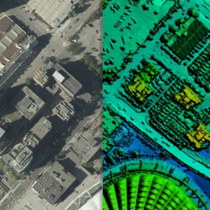
Over the past several years, the Province of British Columbia has made significant investments in LiDAR and has now released provincial LiDAR collections known as LidarBC under the Open Government License. This data is now freely available for anyone to download and use via the LidarBC Open Data Portal. Until recently, British Columbia was without publicly available LiDAR data. This limited access, combined with large file sizes, greatly limited the potential of many in the GIS world to conduct research using this rich data source. The LidarBC program has taken the LiDAR point cloud data from large areas and divided them into smaller, more manageable blocks of data, resulting in file sizes that will not overload browsers. To that end, the Portal uses a provincial map divided by tiles that allows users to locate the data they want precisely, without obtaining necessary excess data. This new tool, developed by Caslys Consulting, also contains a user-friendly interactive guide that shares valuable information on the step-by-step processes needed to use LidarBC’s Open LiDAR Data Portal. What is LiDAR? LiDAR (Light Detection And Ranging) is a uniquely accurate method for elevation acquisition, acting as an active remote sensing system that produces its own energy for acquisition of information. These LiDAR systems are made up of a laser, scanner and GNSS (GPS) receiver that are mounted onto an aircraft. The systems transmit short, high-frequency wavelengths of light to a surface, then record the time of flight and intensity of the back scatter returned to the sensor that make up a point cloud data set. The high spatial resolution of the resulting surface models allows the differentiation of many fine terrain features in both urban and natural environments. The Province of British Columbia now has this powerful active remote sensing system of LiDAR point cloud and derivative data […]
Continue readingOur response to COVID-19
Caslys is paying close attention to the evolving COVID-19 global situation and following the recommendations posted by federal and provincial health officials. We are committed to adapting our approach as new information becomes available. Hybrid work environment Our Caslys team is currently working under a hybrid work environment. Our office is open and most of our team work in the office part-time; and work part-time remotely. Each of our team members has full access from their home-office locations to our online data, email, and GoToMeeting screen sharing services, so we are able to fulfill all of our contractual obligations and project deliverables with no reduction to any of our services. COVID-19 safety plan Our COVID-19 Safety Plan (available here) outlines measures that we are taking to reduce the risk of COVID-19 transmission in our workplace. Contact us If you have any questions or concerns about our work-from-home policy or our COVID-19 Safety Plan, please feel free to contact either of our owners via phone or email: Luanne Richardson (lrichardson@caslys.ca; 250-884-6481) or Jason Shaw (jshaw@caslys.ca; 250-686-8801). Last updated: 2022-07-11
Continue readingCOVID-19 Isolation and Air Quality in Canada
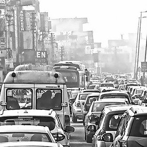
There was a fair bit of press given to the impact that COVID-19 isolation or lockdown had on air quality in China and northern Italy – two places hard hit by this pandemic and also two places with particularly poor air quality due to industry, transportation and to some extent geography. As our Caslys team began working remotely from home, we wondered how air quality was being impacted here in Canada. So, we leveraged our earth observation skills and tools that we typically use to monitor the Earth’s surface and ventured into the atmosphere. We downloaded data from the Sentinel-5P Troposheric Monitoring Instrument to replicate what we saw in the news overseas. The focus was on nitrogen dioxide (NO2) that comes in large part from the combustion in our cars or the burning of fossil fuels for energy or industry. The Sentinel-5P satellite is able to map a variety of other parameters (listed in the website screen capture above), which may have applications for all sorts of air quality monitoring, but we focused solely on nitrogen dioxide to satisfy our curiosity. To avoid some of the seasonal variation, we plotted the average NO2 concentrations for the period when our local isolation began and the same seasonal range from one year earlier (March 2019 compared to March 2020). We also checked May 2020 to see if the lockdown is still influencing air quality. We looked into a couple of hotspots near Prince Albert, Saskatchewan and found that forest fires were the cause of lower air quality. We plotted the results over the National Geographic basemap service to see the hotspots and the generally improved air quality during isolation. In the images above, the highest concentrations of NO2 in the atmosphere are shown in purple – fading to orange and yellow. The […]
Continue reading