Our remote sensing team at Caslys highlights surface water detection methods in a case study of Northern Alberta and the Peace-Athabasca region. This delta and its dynamic hydrologic environment is a strong example of an area that experiences a high degree of change in surface water levels annually. Check out the article below to see our results and learn more about surface water detection!
What is surface water?
Surface water refers to any body of water found on the Earth’s surface, encompassing both saltwater and freshwater sources. Freshwater surface bodies such as rivers, streams, and lakes are essential for maintaining ecosystems by providing habitats for diverse plant and animal species. Additionally, they support numerous human activities, including drinking water supply, irrigation, wastewater treatment, livestock management, industrial processes, hydro power generation, and recreational activities.
The presence of surface water varies in response to a variety of driving forces including, but not limited to: human activity, environmental change, and climate. Forest fires, floods, rising temperatures, urban and industrial development, as well as other climate factors and human activities all can impact surface water presence. Due to its volatile nature, available hydrologic spatial datasets often overlook seasonal surface water changes. The gap in up-to-date hydrologic data can be filled with raster-based time series approaches that allow us to view hydrology in a more dynamic way. The resulting surface water layers are important for effective planning and decision making in multi-use landscapes.
Case Study: The Peace-Athabasca Delta
Northern Alberta is home to one of the world’s largest inland freshwater deltas. The area serves as a refuge for more than one million migratory birds each year, as habitat for 270 animal species; including the globe’s largest free-roaming herd of wood bison, as an enclave for native grasses and sedge’s and as the lifeblood for the local Cree, Chipewyan and Métis people. This combination of outstanding ecological and biological attributes led to the designation of Wood Buffalo National Park as a UNESCO World Heritage Site in 1983.
The Peace-Athabasca Delta is a landscape hole-punched with small ponds and lakes. These bodies of water and the channels that connect them rely on seasonal floods to replenish their water levels. The complex hydrological dynamics of the delta are influenced by various factors, including precipitation levels, beaver activity, wind direction, river ice volumes and ice jams, as well as, the operations of several dams located on the delta’s major water way. Observing and understanding surface water dynamics of the delta are vital for maintaining ecological integrity and the cultural practices of Indigenous communities.
Case Study Data
Strong data quality increases the accuracy of analysis and ensures that the information is reliable, accurate and complete. The input data for this project was derived from Caslys CARD Stack services and includes:
- Sentinel Surface Water Dynamics Products: Annual Water Occurrence (2020-2024)
- Landsat-based JRC Global Surface Water Layers v1.4: Long-term Water Occurrence
For this analysis, the Sentinel and Landsat water occurrence layers are both presented on a scale from 0-100 with higher values indicating more permanent water surfaces and lower values indicating more temporary water surfaces (e.g., water bodies are only available during seasonal flooding events).
Methods
Although Sentinel-based and Landsat-based surface water dynamic layers (SWDL) differ in the available time frames and resolution, they both follow a similar process.
First, a binary surface water mask is created for each satellite image in the study period, where “1” represents water pixels and “0” represents non-water pixels. These water masks are summed to determine how many times water is detected at each pixel throughout the study area. The cumulative water mask is divided by the total number of available images to calculate the water occurrence values, which range from 0 to 1. To make these values more interpretable, they are rescaled to values ranging from 0 to 100, indicating the percentage of time that water is present at each pixel. Landsat provides long-term historical data (since the 1970s), while Sentinel satellites (since 2019) offer improved spatial / temporal resolution and radar capabilities. Combining Landsat and Sentinel observations allows for a more complete view of surface water and its changes over time.
Results
It is important to note that different time frames can be used as an input to the SWDL algorithms. This enables a user the ability to extract water dynamics for a short or long period of time. A combination of multiple study periods (e.g., annual, 5-year, 10-year, 20-year) offers a comprehensive observation of water dynamics across a study area.
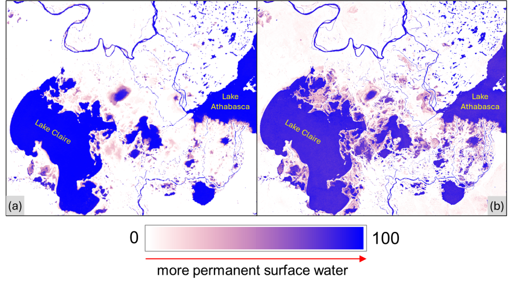
Figure 1 illustrates the long-term (1984-2021, Landsat-based) and short-term (2020-2024, Sentinel-based) water occurrence in the Peace-Athabasca basin, highlighting the frequency and distribution of surface water in the study area. Permanent water bodies are shaded in blue, representing areas with consistent water presence throughout the study periods. In contrast, seasonally flooded or temporary water surfaces are shown in light pink to purple. The mapped results highlight the profound hydrological dynamics of the delta particularly in the region between Lake Claire and Lake Athabasca where a large portion of the land is subject to seasonal flooding.
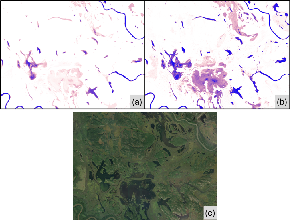
Compared to the Landsat-based product, which offers a long-term perspective on surface water dynamics, the Sentinel-based map provides a finer spatial resolution (10-m vs. 30-m), enabling the detection of small water bodies (Figure 2). Additionally, the use of Sentinel-1 SAR imagery improves the ability to detect surface water, particularly under conditions where optical sensors might be limited (e.g., water surface partially covered by vegetation).
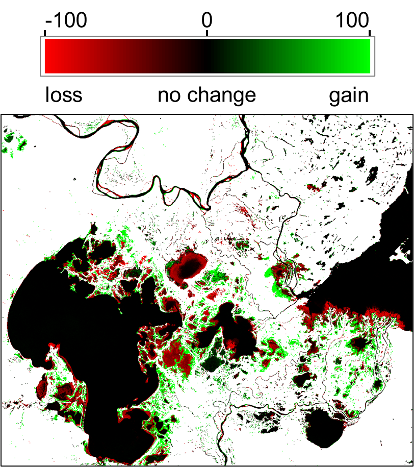
In the Peace-Athabasca Delta, residents have observed fewer spring floods and drying basins (as water is replaced by encroaching vegetation). These changes can be verified and tracked by comparing water occurrence across multiple shorter periods. For example, Figure 3 highlights changes in water occurrence before and after the year 2000. Areas shaded in red represent water loss, while green-shaded areas indicate water gain. The intensity of the color reflects the magnitude of the changes.
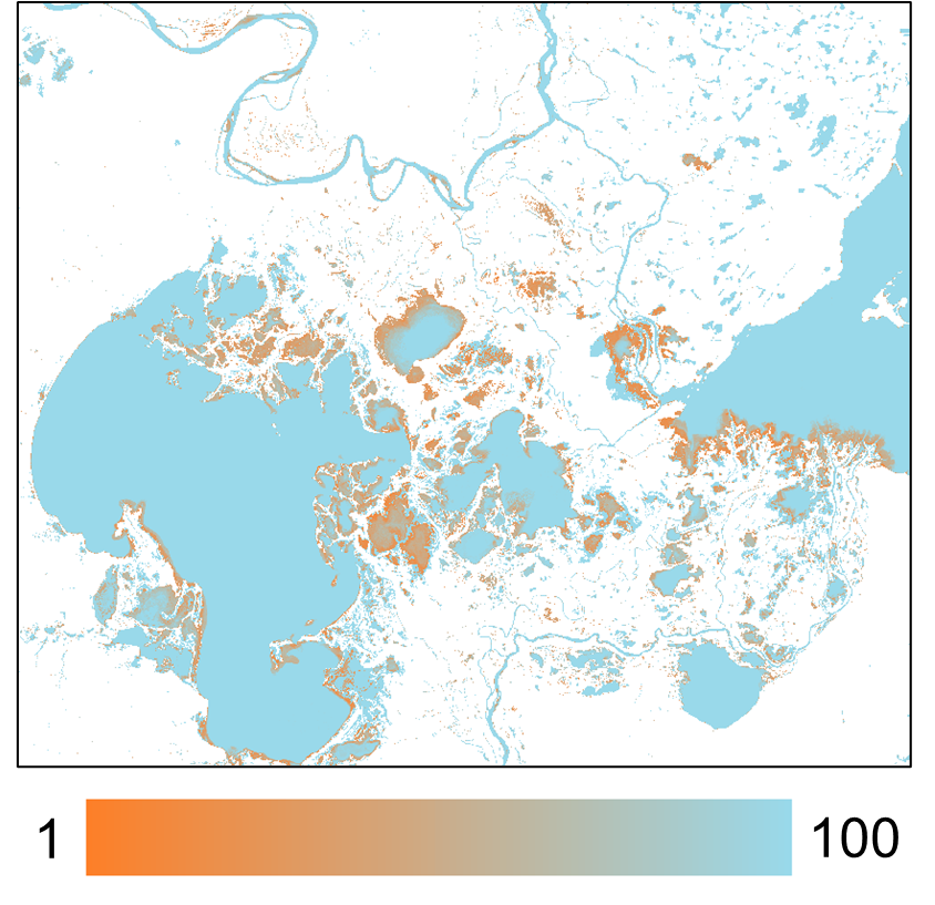
In addition to analyzing water frequency and changes, examining water recurrence provides further insight into the long-term water dynamics of the Peace-Athabasca Delta (Figure 4). Water recurrence measures how often water returns from one year to the next, expressed as a percentage. By analyzing this layer, we can identify temporary water bodies that flood annually as well as those that flood less frequently year-to-year (shaded in orange). These areas may correspond to new gains or losses (as shown in Figure 3) or may only flood during extreme events.
Our analysis presents a clear example of how to assess surface water dynamics using water occurrence, recurrence, and change layers in the Peace-Athabasca Delta. By generating and comparing these layers across various study periods, both short- and long-term, we can achieve a deeper understanding of the delta’s complex hydrology from both spatial and temporal perspectives. This comprehensive approach provides valuable insights for decision-making, particularly concerning sustainable development and the conservation of water resources, ecology, economy, and cultural heritage in this world’s greatest freshwater delta.
About Caslys
For over 20 years, Caslys Consulting Ltd. has taken pride in offering a wide range of high-quality geospatial services for both environmental and natural resource management industries.
Our focus is on interpreting and analyzing data to deliver cost-effective solutions and help our clients make better informed decisions. We specialize in Geographic Information Systems (GIS), remote sensing, information management and application development to meet the needs of both public and private sector clients within Canada and abroad.
As a company, Caslys Consulting combines strong technical skills in our specialized fields with the ability to effectively communicate technical results and complex products to help show our clients how it can be used for meaningful decision making. We also understand the importance of sustainability and take pride in promoting sustainable initiatives and practices to help improve the communities we are working in.
Caslys Consulting Ltd. acknowledges and respects the Lək̓ʷəŋən peoples and W̱SÁNEĆ Nations on whose traditional territory the Caslys office is located. We thank them for their strength and resilience in protecting this land and aspire to uphold our responsibilities according to their example.
We want to hear from you! Connect with Caslys today to learn more about our services and how our spatial data specialists can help your projects succeed.